


 Written by
 Beneath the fields that feed the nation, two vast aquifers are running dry.
The science is clear, the economics are brutal, and the clock is ticking.
The water that sustains America’s agricultural heartland did not fall from the sky last season. It seeped underground over thousands to millions of years, pooling in vast geological formations called aquifers. Now, in the span of a single human lifetime, farmers and cities are pumping it out faster than nature can replace it — and in many places, nature can barely replace it at all.
Two aquifers sit at the center of this crisis: the Ogallala, which stretches beneath eight states from South Dakota to Texas and supplies 30 percent of all U.S. irrigation groundwater, and the Central Valley Aquifer, which underpins California’s fruit, nut, vegetable, and dairy industries — accounting for 18 percent of total U.S. crop value. Together, they are the hydrological backbone of American food production. Both are collapsing.
Without aggressive water management, structural legal reform, and a rapid shift toward sustainable farming practices, the depletion of these resources risks destabilizing the nation’s food supply and transforming once-fertile plains back into arid dust bowls. That is not hyperbole. It is the consensus of federal scientists, satellite data, and generations of hydrological research.
The Ogallala Aquifer: Mining a Fossil Resource
The Ogallala Aquifer spans roughly 174,000 to 175,000 square miles across eight states — South Dakota, Nebraska, Wyoming, Colorado, Kansas, Oklahoma, New Mexico, and Texas. In the Oklahoma Panhandle alone, it supplies more than 98 percent of total water demand. It is not just important to the region’s economy. It is the region’s economy.
The U.S. Geological Survey has tracked what is happening beneath those fields with unflinching precision. From predevelopment to 2015, the average area-weighted water-level change across the entire aquifer was a decline of 15.8 feet. Total recoverable water in storage dropped to 2.91 billion acre-feet — a net loss of 273.2 million acre-feet, or 9 percent of the aquifer’s predevelopment volume.
The numbers get worse state by state. Texas recorded an average annual water-level decline of 18.0 inches per year between 2013 and 2015, with historical maximum declines of 256 feet in some individual wells. Kansas lost 14.4 inches per year on average over the same period; some areas have seen historical drawdowns exceeding 100 feet. The Oklahoma Panhandle tells a similar story: Texas County down more than 70 feet, Cimarron County more than 50 feet. Western Kansas has already used up to 60 percent of its groundwater reserves in some areas.
Not every state is in crisis. Nebraska shows a net gain — rises of up to 85 feet in some areas — owing to wetter conditions and different local geology. That contrast is important: it proves conservation and recharge are physically possible. It also makes the southern states’ failure to replicate Nebraska’s outcomes more damning.
A critical subregion — just 14 percent of the Ogallala’s total area — accounts for 25 percent of all agricultural water demand in the Great Plains, producing irrigated crops valued at up to $7 billion. That concentrated pressure on a small slice of the aquifer accelerates drawdown precisely where the water is most productive and, in many places, shallowest.
“Parts of western Kansas have already pumped out 60% of their groundwater. At current rates, some areas will reach the point of no return within a generation.”
— USGS High Plains Aquifer Water-Level Monitoring
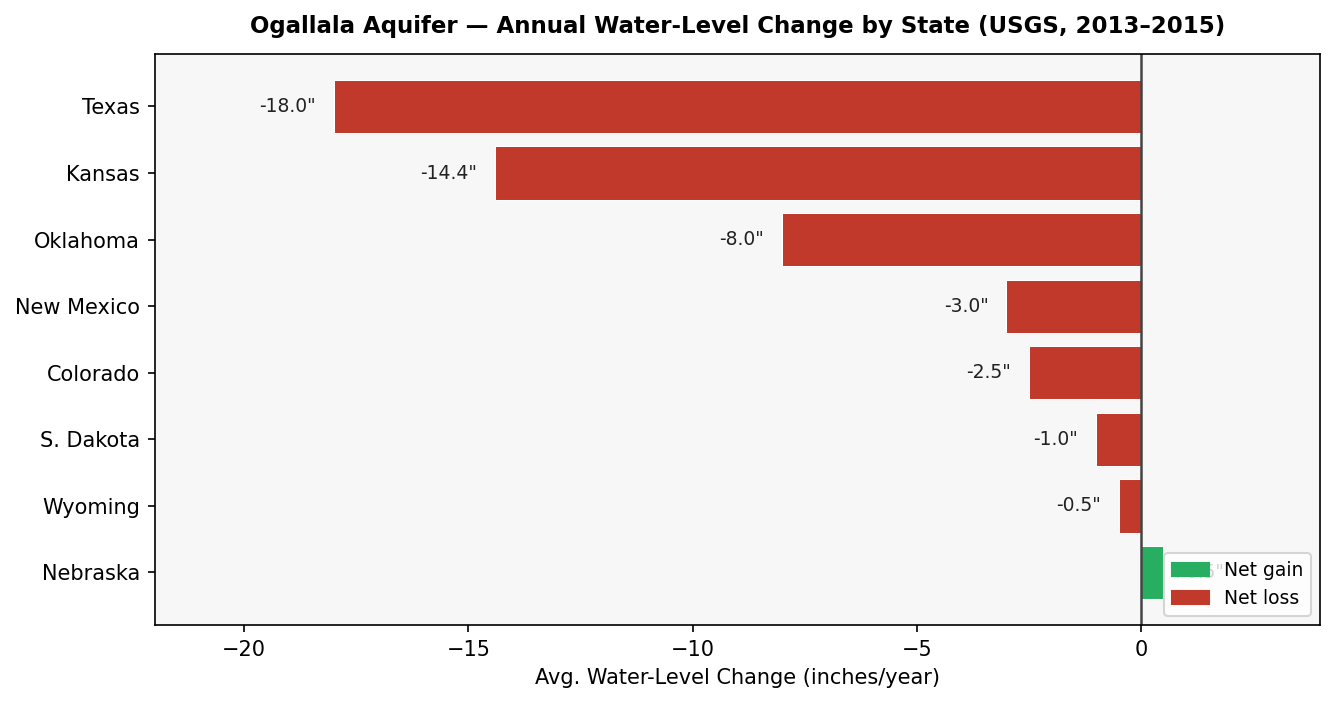
Figure 1: Annual water-level change by state, 2013–2015 (USGS). Nebraska records a net gain; Texas leads net losses at –18.0 inches/year.
One policy detail rarely makes headlines but accelerates the crisis: since 1965, the federal government has classified Ogallala groundwater as a non-renewable resource — and simultaneously permits irrigating farmers to claim tax depreciation allowances for documented water-level declines beneath their land. The perverse result: depleting a shared, public resource generates a private tax benefit, rewarding the fastest pumpers.
California’s Central Valley: The Ground Is Collapsing
California’s Central Valley produces almonds, pistachios, tomatoes, grapes, and dairy at a scale that makes it one of the most productive agricultural regions on Earth — roughly 18 percent of total U.S. crop value flows from this valley. In normal water years, groundwater supplies one-third of California’s agricultural needs. During droughts, that share rises to two-thirds or more. And California is in drought more often than not.
NASA’s GRACE and GRACE-FO satellites have measured the aquifer’s mass loss from space with a precision impossible from ground wells alone. The numbers they have returned over 60 years are staggering. From 1962 to 2021, the Central Valley Aquifer lost an average of 1.86 km³ of water per year — a total net loss of 111.5 km³. During the megadrought cycle from 2003 to 2021, that annual rate accelerated to 2.41 km³ per year.
Then came 2019 to 2021. During that drought cycle, the depletion rate exploded to 8.58 km³ per year — nearly five times the 60-year long-term average. To grasp that number: one cubic kilometer of water is roughly 811,000 acre-feet, or enough to supply the annual needs of approximately 3 million American households.
“During the most recent drought cycle, the Central Valley’s depletion rate hit 8.58 km³ per year — nearly five times the long-term average.”
— NASA GRACE-FO Satellite Analysis, 2019–2021

Figure 2: Central Valley Aquifer depletion rate by period (NASA GRACE satellite data). The 2019–2021 rate was nearly five times the 60-year baseline.
But overdraft does more than drain a reservoir. It destroys the reservoir itself. When clay-rich aquifer layers are over-pumped, they compact irreversibly — permanently eliminating storage capacity that cannot be recovered even if water returns. Between 2007 and 2010 alone, the Central Valley permanently lost approximately 2 percent of its total aquifer storage capacity.
That geological collapse has affected over 4,000 square miles of the valley floor, warping irrigation canals, cracking roads, and undermining building foundations. Land subsidence in some areas has exceeded several feet. And between 2020 and 2024, falling water tables left more than 1,300 domestic wells dry. Tulare County bore the worst of it, stripping rural communities of drinking water access entirely.
The Economic Reckoning
The Ogallala Aquifer sustains a $35+ billion agricultural economy across the High Plains. That figure will shrink steadily as the water disappears — not all at once, but through a slow, grinding economic erosion that economists have already modeled in precise terms.
The average annual present value of returns to agricultural land in the High Plains is projected to fall by $126.7 million by 2050 and by $266.0 million by 2100 as saturated thickness declines. When aquifer depth drops below 70 feet — the threshold below which many pump systems become uneconomical — roughly 67 percent of the economic damage comes from reduced irrigated acreage, as farmers are forced into dryland farming. The remaining 33 percent comes from falling land rental rates.
Kansas offers a concrete historical example. Between 1996 and 2005, increased groundwater withdrawals in the state’s High Plains reduced the state’s total wealth by $1.1 billion. The water extracted in those years generated short-term profit while permanently degrading the asset base underlying it.
The Fourth National Climate Assessment warns explicitly that global warming combined with aquifer decline will threaten the food security of millions of Americans. Transitioning to dryland crops — while necessary — carries its own trade-offs: substituting peas into a wheat-corn-proso millet rotation, for example, can reduce subsequent wheat and corn yields, cutting net farm income in the transition years.
“Between 1996 and 2005, increased groundwater withdrawals in Kansas’s High Plains reduced the state’s wealth by $1.1 billion.”
— Kansas Geological Survey Economic Analysis
Echoes of the Dust Bowl: History’s Warning
Americans have seen what happens when the Great Plains runs out of water. The 1930s Dust Bowl remains the most severe human-triggered ecological disaster in the nation’s history — triggered not by a single mistake but by a cascade of agricultural decisions that stripped the land of its natural defenses.
Deep plowing broke native sod that had anchored the soil for millennia. The region’s deep-rooted shortgrass prairie — which had survived centuries of drought — was replaced by shallow-rooted cotton left bare in winter and crop stubble burned to control weeds. Then the drought came: three waves in 1934, 1936, and 1939–1940. In 1932, only 12 inches of rain fell near Boise City, Oklahoma — less than half what a crop requires to survive.
The consequences were civilizational. By 1937, 21 percent of all rural Great Plains families were on federal emergency relief. The drought and erosion affected 100 million acres, centered on the Texas and Oklahoma Panhandles.
History does not repeat itself — but it rhymes. Western Kansas has now consumed up to 60 percent of its groundwater in some areas. The land those farmers are working was labeled by 1880s cartographers the ‘Great American Desert.’ Without rapid changes to irrigation technology, farmer behavior, and groundwater law, the High Plains could once again earn that name.
Regulation: A Fragmented, Uneven Response
Groundwater in the United States is governed at the state and local level. There is no unified federal framework. Adjacent landowners tapping the same aquifer can operate under completely different legal doctrines — and the results could not be more different.
Texas — Rule of Capture
Texas operates under the ‘Rule of Capture’: landowners own every drop of water beneath their feet and can pump it without limit, regardless of what that does to their neighbors’ wells or the aquifer as a whole. Combined with the federal tax write-off for depletion in place since 1965, this has produced a textbook tragedy of the commons. Water levels in some Texas wells have declined up to 256 feet.
Nebraska — Decentralized Natural Resources Districts
Nebraska took a different path. The state Supreme Court adopted a ‘correlative use’ doctrine in 1933. By 1972, the state had created 23 Natural Resources Districts (NRDs); by 1975, those NRDs had legal authority to regulate groundwater. The result is visible in the data: while Texas bleeds 18 inches per year, Nebraska records net gains.
NRDs have two primary tools. Well moratoria — bans on new well drilling — effectively prevent expansion of irrigation capacity, but dryland parcel values fell by roughly 9 percent (approximately $200 per acre) as the option value of future irrigation disappeared. Flexible volumetric allocations, which set pumping limits but allow carry-over of unused water between years, proved superior: farmland values stayed stable, water use stabilized, and crop yields and profits were unharmed.
Kansas — Local Enhanced Management Areas (LEMAs)
Kansas established the LEMA framework in 2012 via SB 310. The Sheridan-6 LEMA, launched in 2013, was the first community-led conservation zone in the state. Farmers voluntarily agreed to reduce water use by 20 percent from historical allocation — 55 inches per acre over five years.
What happened exceeded every expectation. Over five years, actual water savings hit 39 percent — nearly double the target. The annual water-table decline slowed from 2.0 feet per year in the decade before LEMA to just 0.5 feet per year afterward. The Kansas Geological Survey attributed 23 percent of the savings to increased irrigation efficiency; only 1 percent came from reduced irrigated area. The rest came from crop switching: sorghum production rose 335 percent, while water-intensive corn fell 23 percent. Sheridan-6 farmers also reported 4.3 percent more cash flow than neighbors outside the LEMA boundaries.
“Sheridan-6 farmers saved 39% more water than required — and made 4.3% more cash than their neighbors.”
— Kansas Geological Survey, Sheridan-6 LEMA Analysis
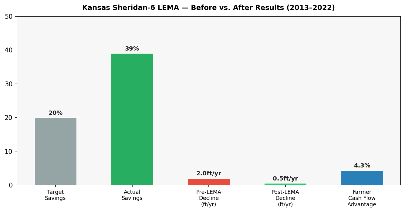
Figure 3: Sheridan-6 LEMA results — target vs. actual water savings, water-table decline rates before and after, and farmer cash flow advantage vs. non-LEMA neighbors (2013–2022).
California — Sustainable Groundwater Management Act (SGMA, 2014)
SGMA is the most significant water legislation California has passed in decades. It requires local Groundwater Sustainability Agencies (GSAs) to achieve sustainability — critically overdrafted basins by 2040, medium- and high-priority basins by 2042. Those high- and medium-priority basins account for roughly 95 percent of all groundwater pumping in the state.
GSAs must prevent six ‘undesirable results’: water level declines, storage reductions, seawater intrusion, water quality degradation, land subsidence, and streamflow depletion. Progress as of California Bulletin 118 (spring 2026) shows over 1,500 projects and management actions assembled. Annual managed recharge averaged 2.5 million acre-feet across water years 2022 through 2024, totaling 7.4 million acre-feet. The LandFlex Grant Program allocated $25 million to compensate growers who voluntarily reduced pumping — saving over 100,000 acre-feet and protecting 16,500 drinking water wells.
From 2014 to 2024, 41 percent of monitored wells saw water levels rise 5 feet or more; 20 percent declined 5 feet or more. Land subsidence remains active: approximately 4,000 square miles have sunk more than 0.5 feet over five years. Enforcement has sharpened: multiple critically overdrafted basins are under probationary status, and pumpers in the Tule and Tulare Lake subbasins now submit extraction reports and pay state-imposed fees.
But compliance carries an economic sting. Achieving the average 19.2 percent pumping reduction target through pricing would require a 60 percent pumping tax — shifting 9 percent of cropland, causing a 24 percent decline in fruit and nut orchards, and a 50 percent increase in fallowed land. The transition is real and painful.
| Framework | Region | Legal Authority | Economic Impact | Hydrological Result |
| Rule of Capture | Texas | Landowner owns groundwater; no limits | Short-term gains; long-term wealth loss | Wells down up to 256 ft; fastest depletion |
| Well Moratoria | Nebraska NRDs | NRD bans new well drilling | Dryland parcel values fell ~9% (~$200/acre) | Prevents expansion; does not cut existing use |
| Flexible Allocations | Nebraska NRDs | Volumetric pumping caps with carry-over | Stable farmland values; yields unchanged | Water use stabilized; preferred tool |
| LEMA | Kansas | Community-negotiated volumetric limits | 4.3% more cash flow for LEMA farmers | Decline slowed from 2.0 to 0.5 ft/year |
| SGMA | California | State-mandated GSA sustainability plans | 60% tax needed to hit targets; major crop shifts | 41% of wells rising; subsidence ongoing |
The Legal Trap Blocking Crop Switching
Across most western states, water rights are real property. When a farmer sells or transfers a water right, only the ‘historical consumptive use’ — what the previous crop actually consumed — can be legally transferred, not the full decreed diversion.
The consequence is a legal lock-in. Growing high-water-use crops like alfalfa or cotton establishes a high historical consumptive use, making the water right more valuable. Switching to drought-tolerant crops permanently reduces the legal and financial value of the right. Farmers who want to conserve water face a direct financial penalty for doing so: they are protecting the aquifer at the cost of their own property value.
This rule must be reformed. States must allow permit holders to reduce consumptive use without forfeiting water rights. Until they do, the legal system will continue rewarding the very behavior that is draining the aquifer.
What Works: Technology and Crop Alternatives
Drought-Tolerant Crop Alternatives
The shift away from water-intensive corn and cotton is both agronomically feasible and economically viable — as the Sheridan-6 data proved. Several crop classes show strong potential:
| Crop | Water Requirement | Yield Potential | Key Advantage | Key Constraint |
| Grain Sorghum | 350–400 mm/year | 2–6 tons/acre dry matter | Highly drought-tolerant; deep-rooted | Lower market price than corn silage |
| Pearl/Proso Millet | 300 mm/year | 1.5–3 tons/acre | Semi-arid adapted; very low water need | Limited domestic commercial market |
| Spring Triticale | Moderate | 2.5–3 tons/acre | High feed value; similar to early alfalfa | Higher seed cost |
| Italian Ryegrass | Moderate | 3–5 tons/acre | Multiple cuttings from late April | Sensitive to extreme winter freezes |
| Annual Forages (barley/oats/triticale) | Low | Up to 2 tons/acre | Outperform dryland alfalfa in dry trials | Require rotation management |
Irrigation Technology Upgrades
The efficiency gap between old and new irrigation technology is enormous — and closing it represents the single fastest path to reducing aquifer withdrawals without reducing crop output.
Traditional center-pivot systems deliver water with roughly 60 percent application efficiency: 40 cents of every dollar spent on pumping is lost to evaporation and wind drift. Low-Elevation Spray Application (LESA) — which places nozzles just 12 to 18 inches above the soil at 6 to 15 psi — pushes efficiency to 88 to 97 percent. Low-Energy Precision Application (LEPA) delivers water directly to the soil via drop-socks or bubbler nozzles at 6 to 10 psi, achieving 95 percent efficiency or better while also cutting pumping energy costs. Mobile Drip Irrigation (MDI), which drags drip lines on the soil surface from center-pivot drop hoses, eliminates wind drift entirely and reduces runoff risk versus LEPA.
Soil moisture monitoring technology — including cosmic-ray probes and passive microwave reflectometry — enables spatial mapping of crop water availability, allowing variable-rate irrigation applied only where and when it is needed. Precision beats volume, every time.
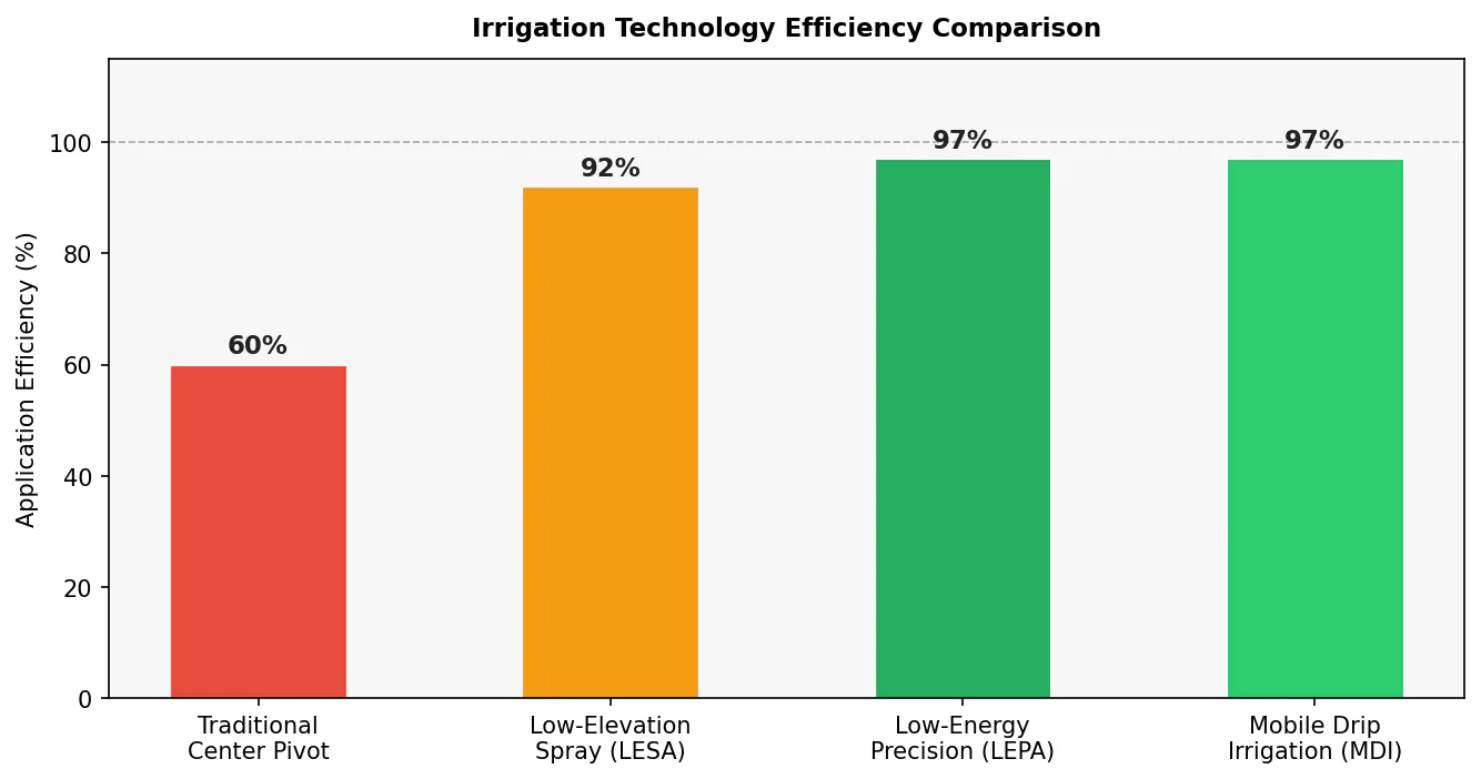
Figure 4: Irrigation technology efficiency comparison. LEPA and MDI achieve 95%+ efficiency — more than 35 percentage points better than traditional center pivots.
Six Things That Must Happen
1. Create a National Aquifer Protection Commission. Congress must establish a bipartisan federal body to coordinate transboundary groundwater data, standardize aquifer health metrics across state lines, and manage interstate resources like the Ogallala. No such coordinating authority currently exists. The aquifer does not respect state boundaries; the law should not either.
2. Mandate telemetry meters and pumping limits on every commercial well. States must require calibrated flow meters on all commercial agricultural wells. Administrative pumping limits, modeled on the Kansas LEMA framework, must align withdrawals with recharge rates — not historical averages or economic expectations.
3. Reform the historical consumptive use rule. Western states must allow permit holders to conserve water without losing the financial value of their water rights. The current rule is an economic trap that keeps farmers locked into high-water crops to protect their property. Reforming it is the single most important legal change available.
4. Restructure Farm Bill subsidies around water conservation. Expand conservation incentives, fund LESA, LEPA, and MDI irrigation technology upgrades at scale, and eliminate crop subsidies for water-intensive crops grown in critically overdrafted basins. The federal government should not simultaneously subsidize the problem and the solution.
5. Implement tiered groundwater pumping fees. GSAs and NRDs should charge escalating fees for overdraft pumping. Revenue funds managed aquifer recharge programs and compensates growers who fallow land or transition to dryland farming. Price the externality or it will not be corrected.
6. Extend planning horizons to centuries, not decades. Water managers must stop planning for 20-year windows and start planning for 200-year ones. Intergenerational sustainability must legally supersede short-term economic yield. The aquifer took millions of years to fill. Planning for a single crop cycle is not stewardship — it is liquidation.
The Reckoning
The Ogallala Aquifer took millions of years to fill. The Central Valley’s clay layers, once compacted, will never recover their storage capacity. At current extraction rates, parts of both systems will be functionally exhausted within a generation — not as a distant possibility, but as a mathematical certainty confirmed by federal satellites, USGS monitoring networks, and decades of peer-reviewed hydrology.
What follows is not a water crisis in isolation. It is a food crisis. The crops that fill American grocery stores — wheat, corn, sorghum, almonds, pistachios, tomatoes, dairy — depend on water being in the ground when farmers need it. Remove the water, and the food system that $35 billion in annual agricultural output represents begins to fracture.
The science is settled. The engineering solutions exist. The legal reforms are identified. What Kansas proved in Sheridan-6, what Nebraska built through its NRDs, and what California is attempting through SGMA all demonstrate that sustainable management is achievable — even if the economics are hard and the transitions are painful.
The only thing missing is the political will to act before the water runs out. Once it does, will is irrelevant.
Works Cited (Click Here)
- Impacts to the Ogallala Aquifer: How Changes in Long-term Weather …,
https://www.climatehubs.usda.gov/sites/default/files/Ogallala%20Overview%20241202.pdf - Aquifer depletion and potential impacts on long-term irrigated agricultural productivity,
https://pubs.usgs.gov/publication/70237799 - Groundwater depletion in California’s Central Valley accelerates …,
https://pmc.ncbi.nlm.nih.gov/articles/PMC9763392/ - USGS: High Plains Aquifer Groundwater Levels Continue to Decline,
https://www.usgs.gov/news/technical-announcement/usgs-high-plains-aquifer-groundwater-levels-continue-decline - The Ogallala Aquifer – Oklahoma State University Extension,
https://extension.okstate.edu/fact-sheets/the-ogallala-aquifer - Protecting Groundwater is Essential for our Country and Economy – United States Joint Economic Committee,
https://www.jec.senate.gov/public/index.cfm/democrats/2024/5/protecting-groundwater-is-essential-for-our-country-and-economy - Study shows how price can impact groundwater use by farmers …,
https://agsci.source.colostate.edu/study-price-groundwater-farmers/ - Groundwater Decline and Depletion | U.S. Geological Survey – USGS.gov,
https://www.usgs.gov/water-science-school/science/groundwater-decline-and-depletion - Dustbowl Waters: Doctrinal and Legislative Solutions to Save the …,
https://lawreview.colorado.edu/print/volume91/dustbowl-waters-doctrinal-and-legislative-solutions-to-save-the-ogallala-aquifer-before-both-time-and-water-run-out/ - The Economic Cost of Groundwater Depletion in the High Plains …,
https://www.journals.uchicago.edu/doi/10.1086/726156 - Chronicle of a Demise Foretold: State vs. Local Groundwater Management in Texas and the High Plains Aquifer System – Water Alternatives,
https://www.water-alternatives.org/index.php/alldoc/articles/vol11/v11issue3/451-a11-3-4/file - Ogallala Timeline,
https://ogallalawater.org/ogallala-timeline/ - SGMA Groundwater Sustainability Statistics 2026: California Data,
https://scwellservice.com/blog/sgma-groundwater-sustainability-statistics.html - Economic Impact of Groundwater Regulation: Case Study of Nebraska,
https://waterforfood.nebraska.edu/news-and-events/news/2025/03/economic-impact-of-groundwater-regulation-case-study-of-nebraska - Sustainable Agriculture – USDA ARS,
https://www.ars.usda.gov/ARSUserFiles/30000000/AD/FY2017%20Annual%20Accomplishments%20(Sustainable%20Farming).pdf - The Dust Bowl | National Drought Mitigation Center,
https://drought.unl.edu/dustbowl/ - Dust Bowl – Wikipedia,
https://en.wikipedia.org/wiki/Dust_Bowl - Rewriting the rules for water use in the High Plains | Science Societies,
https://www.sciencesocieties.org/publications/csa-news/2025/july/rewriting-the-rules-for-water-use-in-the-high-plains - Understanding Groundwater Law – Texas Water Resources Institute,
https://twri.tamu.edu/blog/understanding-groundwater-law/ - Water Management in Nebraska Brochure,
https://dwee.nebraska.gov/sites/default/files/publications/NeDNRWaterManagementBrochure.pdf - Regulations & Policies – UNL Water,
https://water.unl.edu/article/agricultural-irrigation/regulations-policies/ - Kansas Farmers Minimize Water Use as the Southern Great Plains …,
https://howwerespond.aaas.org/kansas-farmers-minimize-water-use-as-the-southern-great-plains-become-more-arid.html - Monitoring the Impacts of Sheridan County 6 Local Enhanced Management Area Interim Report for 2013 – 2015 11/8/2016 Dr. Bill G – AgManager.info,
https://www.agmanager.info/sites/default/files/pdf/Sheridan-LEMA_2013-2015.pdf - Community in Conversation: How Sheridan County, Kansas Communicated Sustainable Change in Water Conservation – Stegmeier Consulting Group,
https://stegmeierconsulting.com/community-in-conversation-how-sheridan-county-kansas-communicated-sustainable-change-in-water-conservation/ - Kansas Geological Survey report assesses health of the High Plains Aquifer | KU News,
https://news.ku.edu/news/article/2023/12/06/kansas-geological-survey-report-assesses-health-high-plains-aquifer - Local Agencies Across California Continue Advancements Toward …,
https://water.ca.gov/News/News-Releases/2026/Mar-2026/Local-Agencies-Across-California-Continue-Advancements-Toward-Groundwater-Sustainability - Sustainable Groundwater Management Act (SGMA) | California State Water Resources Control Board,
https://www.waterboards.ca.gov/sgma/ - Alternatives to Permanent Fallowing Research Synthesis and Outreach – Moving Forward on Agricultural Water Conservation in the Colorado River Basin,
https://www.crbagwater.colostate.edu/files/CWI_Completion_Report232_Part4.pdf - Forage Alternatives for Drought Conditions – MSU Extenison Animal and Range Science,
https://animalrangeextension.montana.edu/forage/forage_alternatives_drought.html - Small-scale farming in drylands: New models for resilient practices of millet and sorghum cultivation – PMC,
https://pmc.ncbi.nlm.nih.gov/articles/PMC9894398/ - Low-Energy Precision Application (LEPA) Irrigation: A Forty-Year Review – ResearchGate,
https://www.researchgate.net/publication/336599335_Low-Energy_Precision_Application_LEPA_Irrigation_A_Forty-Year_Review - Innovations In Center Pivot Irrigation – Vegetables by Bayer,
https://www.vegetables.bayer.com/au/en-au/resources/growing-tips0/innovations-in-center-pivot-irrigation.html - LEPA SOLUTIONS – Nelson Irrigation Corporation,
https://nelsonirrigation.com/library/Pivot_LEPA-LESA-LENA.PDF - Soil Moisture Monitoring – Ogallala Water,
https://ogallalawater.org/soil-moisture-monitoring/ - DUSTBOWL WATERS: DOCTRINAL AND LEGISLATIVE SOLUTIONS TO SAVE THE OGALLALA AQUIFER BEFORE BOTH TIME AND WATER RUN OUT, https://lawschool.unm.edu/faculty/warigia-bowman/bowman_final-dustbowl-waters.pdf